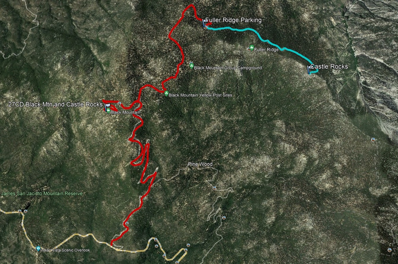
Whimsically named Castle Rocks is the high point of the Fuller Ridge, which continues southeast along with the PCT on their way to San Jacinto Peak. The views of neighboring San Jacinto to the east, the San Bernardinos to the north and the Inland Empire to the south and west are spectacular. It is usually hiked together with Black Mountain #1, a short detour along the drive up.
Route 1 follows the PCT southeast, leaving the trail for a short rocky scramble to the summit.
Maps generated from CalTopo.com, reproduced with permission
Drive I-10 to Banning. Exit at 8th Street (SR 243). Note your odometer and go as follows:
At 0.2 mile, turn left.
At 0.7 mile, turn right on San Gorgonio Avenue.
At 1.4 miles, keep left on SR 243.
At 9.1 miles, Poppet Flat Road goes right. Continue straight.
At 11.6 miles, fork with 4S06 on the right. Keep straight.
At 11.8 miles, pass the Vista Grande Ranger Station.
At 12.8 miles, fork on the left with 2E05 and a sign “Black Mountain Trail”. Keep straight.
At 15.6 miles, fork on the right with 2E35, Indian Mountain Road, and Indian Vista. This is the turnoff for Indian Mountain.
At 16.9 miles, 4S01 on the left. Turn left. Note your odometer and go as follows:
At 1.5 miles, fork. Keep left.
At 4.8 miles, fork with Black Mountain Road on the left. This is the turnoff for Black Mountain #1 (LO). Keep straight on 4S01.
At 5.8 miles, Black Mountain Group Camp on the right.
At 7.2 miles, fork. Turn sharp right.
Continue a short distance to a parking lot for the Fuller Ridge Trailhead of the Pacific Crest Trail (PCT). Park here.
Hiking route
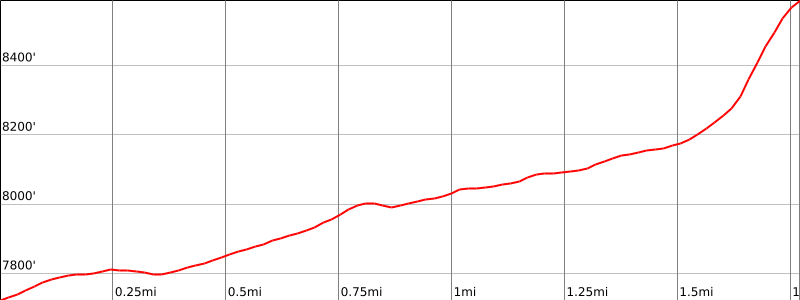
From the trailhead, hike east up the PCT about a mile along the north side of the ridge to where a saddle appears off to the right (8040’+).
Continue on the PCT another 0.6 mile where there should be a duck on the right side of the trail and a sometimes faint, but ducked use trail.
Leave the trail here and go up the slope, keeping somewhat to the right to follow occasional ducks, to the summit.
Special conditions: Wilderness permits are required under all circumstances. Permits for day hikes can be obtained from the Long Valley ranger station (near the tram) for Routes 1 and 3. For Route 2, they may be obtained at the Idyllwild Ranger Stations, as can permits for backpacking. Permits are limited to 12 hikers. The Idyllwild Ranger Station is just off SR 243 at 54270 Pine Crest Road. There is a self- issue permit stand outside of the ranger station. Permits may be obtained in advance from:
San Jacinto Ranger District
54270 Pine Crest Ave.
P.O. Box 518
Idyllwild, CA 92549
Voice: (909) 382-2921
Fax: (951) 659-2107
Historical note: Peak 8462′, 1 mile west-northwest, was listed as Castle Rocks until the new San Jacinto 7½ topo fixed its present location.