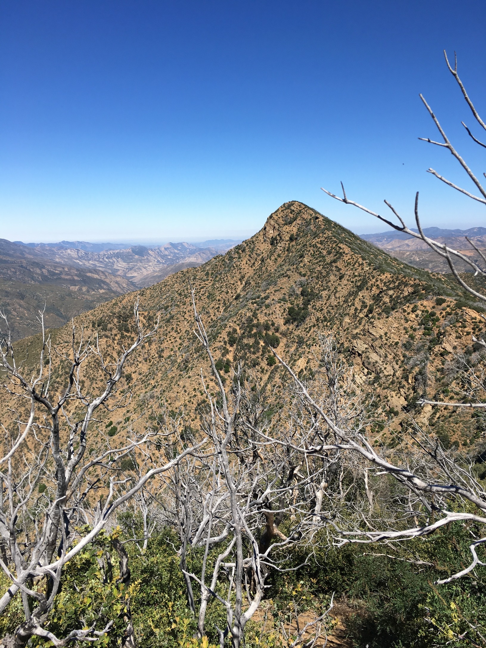
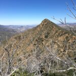
The hike to Samon is only 4.4 miles round trip from Forest Route 9N11 to the summit, but much of it passes through dense chaparral and needs frequent maintenance to remain passable. The use trail zigzags steeply to a bench then across a meadow before climbing to the main ridge where it passes around the first bump on the east, around the second bump on the west, and over the top of the third bump. From this bump the trail follows the ridge to the summit, marked by a benchmark, SAMON. It is slow going.
Samon is generally climbed with Madulce, Big Pine, and West Big Pine on a 3 day backpack trip in spring or fall. Together these peaks are known as the Big Four, and the whole experience is strenuous. There is water at Chokecherry Spring, typically year around, though in the most hot and dry years it may dry up in the late fall. It is possible to hike these peaks as a car camping trip by organizing a service trip with the Los Padres Forest Association, which HPS sponsors periodically.
Maps generated from CalTopo.com, reproduced with permission
Drive north on I-5 past the Grapevine to the SR 166 off-ramp. Turn left (west).
Head west 36.5 miles, passing through Maricopa, to the junction with SR 33 south. This junction may be reached by a slower route via SR 33 north from Ojai. (There is a junction with SR 33 north in Maricopa that you will pass in Maricopa.) Turn left (south).
Go 2.7 miles to Foothill Road on the right. Turn right (west).
Go 2.1 miles, crossing the Cuyama River, to the Santa Barbara Canyon Road (9N11) on the left. Turn left, note your odometer, and go as follows:
At 3.1 miles, just past a ranch house, junction with a dirt road on the left and a paved road on the right with a sign “Santa Barbara Canyon Road”. Turn right.
At 7.5 miles, fork with Santa Barbara Ranch visible ahead. Go right and cross a creek. The pavement ends.
At 9.5 miles, a cattle guard and gate.
At 10.0 miles, a hard to see dirt road on right. This is the turnoff for Fox Mountain #1. Keep straight.
At 10.8 miles, fork with Dry Canyon Road on the left. This is the turnoff for Lizard Head and Cuyama Peak (LO). Keep straight.
At 12.6 miles, a locked gate. Park here.
If the Cuyama River is impassable, return to the junction of SR 166 and SR 33 and go as follows:
Go west on SR 166 for 4.7 miles to a bridge over the Cuyama River, and an immediate junction past the bridge, on your left. This is Kirschenmann Road (paved). Turn left.
Continue 2.4 miles to the end of Kirschenmann at Foothill Road. Turn left (east).
Drive 3 miles to Santa Barbara Canyon Road on the right (south). Turn right and continue as above.
Hiking route
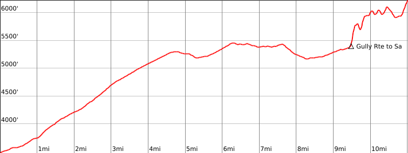
From the parking area (3440′), hike through the small gate (close it after you) and continue up the road.
At 4 miles there are the posts of a second gate; off the road to the right is a flat area suitable for camping.
Continue up the road, keeping left at a fork with Sierra Madre Road about 1/2 mile farther, and go about 5 miles farther to Chokecherry Spring (5500′), marked by a water trough and a large water tank. This is the turnoff for all nearby peaks.
From Chokecherry Spring, go north down the road about 1/4 mile to a narrow gully on the left (west).
Climb up this gully and where it gets tricky, zigzag up the slope to your left to the ridgeline. Be sure to mark this location for your return. (Please note: this route while steep with the potential for some dangerous rock fall is much safer than the old route up Chokecherry Gully). Continue about 200 meters to the top ridge.
At the top, turn left on an old trail cut through the brush. Follow this up the ridge, then down to the right to a meadow. Pick up the trail again at ducks at the north end of the meadow and follow it to the top of the main ridge.
Turn right on the ridge and follow the trail, which goes generally around the first bump on the east, around the second bump on the west, and over the top of the third bump.
From this bump go down along the ridge and up to the summit, marked by a benchmark, ‘SAMON’.
Special conditions: Samon Peak is in the San Rafael Wilderness Area. Campfire permits are required.
This trail gets overgrown, so be prepared! Please perform use trail mainenance.
Samon is generally climbed with Madulce, Big Pine and West Big Pine on a 2-4 day backpack trip, preferably around Easter before the area gets too hot. For all four peaks, the distance is 50 miles, the gain is about 9200′, and the whole experience is strenuous.
There is water at Chokecherry Spring most of the year but it often dries up or has very low flows in drier years; hikers should check on its status before a backpack trip to this area.
If you camp at Alamar, you must carry overnight water 3 miles and about 1000′ gain from Chokecherry Spring or plan to hike down to Bear Camp for water.
Together these peaks are known as the “Big Four”. It is also possible to combine these with the “Big Three” by hiking from West Big Pine to San Rafael Mountain. To do this, use the Mission Pine Trail. It goes west through Mission Pine Basin and on to San Rafael Camp just east of San Rafael Mountain. From there it is a short hike to the summit of San Rafael Mountain. Water in Mission Pine Basin is not reliable.
Statistics for the Big Four:
Trailhead to Chokecherry Spring: 19 miles round trip, 9 hours, 2400′ gain with 300′ on the return.
Chokecherry to Samon Peak: 6 miles round trip, 1900′ gain.
Chokecherry to Madulce saddle: 3.5 miles round trip, 700′ gain, 1.5 hours.
Madulce saddle to Madulce Peak: 7 miles round trip, 4 hours, 1600′ gain.
Madulce saddle to Alamar Station: 2.5 miles round trip, 1.5 hours, 600′ gain on the return.
Alamar station to Big Pine junction: 5.5 miles round trip, 2.5 hours, 800′ gain with 100′ on the return.
Big Pine junction to Big Pine Mountain: 1 mile round trip, 1 hour, 500′ gain.
Big Pine junction to West Big Pine: 5 miles round trip, 2.5 hours, 300′ gain with 100′ on the return.