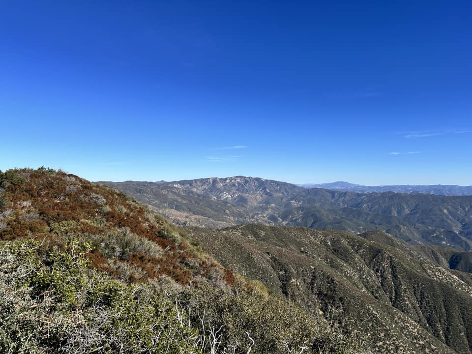
Although West Big Pine is deep in the ruggedly beautiful Santa Barbara backcountry, a road that separates the San Rafael Wilderness from the Dick Smith Wilderness gets you to the Mission Pine Trail. The road is legal for mountain bikes. The trail passes through open chaparral and Jeffery pines close to the summit. This rocky prominence has views of the Pacific Ocean, overlooks spectacular cliffs, and once held a fire lookout. West Big Pine is generally climbed with Samon, Madulce, and Big Pine on a 3 day backpack trip in spring or fall. Together these peaks are known as the “Big Four,” and the whole experience is strenuous.
There is water at Chokecherry Spring, typically year around, though in the most hot and dry years it may dry up in the late fall. It is possible to hike these peaks as a car camping trip by organizing a service trip with the Los Padres Forest Association, which HPS sponsors periodically.
Maps generated from CalTopo.com, reproduced with permission
Drive north on I-5 past the Grapevine to the SR 166 off-ramp. Turn left (west).
Head west 36.5 miles, passing through Maricopa, to the junction with SR 33 south. This junction may be reached by a slower route via SR 33 north from Ojai. (There is a junction with SR 33 north in Maricopa that you will pass in Maricopa.) Turn left (south).
Go 2.7 miles to Foothill Road on the right. Turn right (west).
Go 2.1 miles, crossing the Cuyama River, to the Santa Barbara Canyon Road (9N11) on the left. Turn left, note your odometer, and go as follows:
At 3.1 miles, just past a ranch house, junction with a dirt road on the left and a paved road on the right with a sign “Santa Barbara Canyon Road”. Turn right.
At 7.5 miles, fork with Santa Barbara Ranch visible ahead. Go right and cross a creek. The pavement ends.
At 10.8 miles, fork with Dry Canyon Road on the left. This is the turnoff for Lizard Head and Cuyama Peak (LO). Keep straight.
At 12.6 miles, a locked gate. Park here.
If the Cuyama River is impassable, return to the junction of SR 166 and SR 33 and go as follows:
Go west on SR 166 for 4.7 miles to a bridge over the Cuyama River, and an immediate junction past the bridge, on your left. This is Kirschenmann Road (paved). Turn left.
Continue 2.4 miles to the end of Kirschenmann at Foothill Road. Turn left (east).
Drive 3 miles to Santa Barbara Canyon Road on the right (south). Turn right and continue as above.
Hiking route
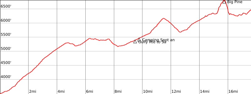
From the parking area (3440′), hike through the small gate and continue up the road. At 4 miles there are the posts of a second gate; off the road to the right is a flat area suitable for camping.
Continue up the road, keeping left at a fork with Sierra Madre Road about 0.5 mile farther, and go about 5 miles farther to Chokecherry Spring (5500′), marked by a water trough and a large water tank. This is the turnoff for Samon Peak.
Continue south up the road about 1.7 miles (700′ of gain) to a saddle where the road starts downhill. About 30 yards past the saddle, a trail starts off to the left, visible from the saddle. This is the turnoff for Madulce Peak.
Continue on the road about 1.2 miles to a fork. The left fork leads a short distance to the old Alamar station site. This is an excellent dry campsite.
Take the right fork and continue 2 miles to where a jeep road goes up the slope to the left.
Continuing on the main road leads to West Big Pine. Instead, turn left and ascend the jeep road, which becomes a use trail near the broad flat summit. The register is located on a rock outcrop at the apparent high point.
Alternate route: If coming from Big Pine Mountain, it is possible to descend cross-country through brush along the southwest ridge of Big Pine to the road. Keep to the right side of the ridge to avoid the worst of the brush. This places you on the main road just west of the trail to Big Pine Campground.
Notes: The road that goes past Chokecherry Spring separates Dick Smith Wilderness, on the east, from San Rafael Wilderness, on the west. The road itself is not Wilderness and is suitable for mountain bikes.
West Big Pine is generally climbed with Madulce Peak, Big Pine Mountain and Samon Peak on a 3-day backpack trip called “The Big Four”. For all four peaks, the distance is 45 miles, the gain is about 8000′, and the whole experience is very strenuous.
There is water at Chokecherry Spring most of the year but it often dries up or has very low flows in drier years; hikers should check on its status before a backpack trip to this area.
If you camp at Alamar, you must carry overnight water 3 miles and about 1000′ of gain from Chokecherry Spring. Bears frequent the area, so it is advisable to bear proof foodstuffs and other consumables when leaving your campsite.
Statistics for the Big Four:
Trailhead to Chokecherry Spring: 19 miles round trip, 9 hours, 2400′ gain with 300′ on the return.
Chokecherry to Samon Peak: 6 miles round trip, 1900′ gain.
Chokecherry to Madulce saddle: 3.5 miles round trip, 700′ gain, 1.5 hours.
Madulce saddle to Madulce Peak: 7 miles round trip, 4 hours, 1600′ gain.
Madulce saddle to Alamar Station: 2.5 miles round trip, 1.5 hours, 600′ gain on the return.
Alamar station to Big Pine junction: 5.5 miles round trip, 2.5 hours, 800′ gain with 100′ on the return.
Big Pine junction to Big Pine Mountain: 1 mile round trip, 1 hour, 500′ gain.
Big Pine junction to West Big Pine: 5 miles round trip, 2.5 hours, 300′ gain with 100′ on the return.