• HOME
  • HIKE WITH US
    • Peak Guides
    • Outings
    • HIKE FINDER
    • Emblems
    • Archives
  • ABOUT
    • About Us
    • Newsletter
    • FAQ
  • CONNECT
    • Membership
    • Merchandise
    • Subscribe
    • Follow Us on Facebook
    • Sierra Club
    • Donate
    • Contact US
LOG IN
LOG IN
  • HOME
  • HIKE WITH US
    • Peak Guides
    • Outings
    • HIKE FINDER
    • Emblems
    • Archives
  • ABOUT
    • About Us
    • Newsletter
    • FAQ
  • CONNECT
    • Membership
    • Merchandise
    • Subscribe
    • Follow Us on Facebook
    • Sierra Club
    • Donate
    • Contact US

Tehachapi Mountain

USE AT YOUR OWN RISK

03E

Tehachapi Mountain

7960'+

Location: Kern County, about 6 miles south-southwest of Tehachapi, 113 miles from Los Angeles

Maps

Auto ClubKern County
USGS TopoTehachapi South 7½
Official HPS Maps TPO file - Save to your computer then open with National Geographic TOPO!
 Viewable JPG file - Approximately 360K
 GPX file or Google Earth KML file to download to GPS units and other map software (How to use GPX and KML files)
 Routes as shown on CalTopo using the above files (How to use CalTopo)

ROUTE 1

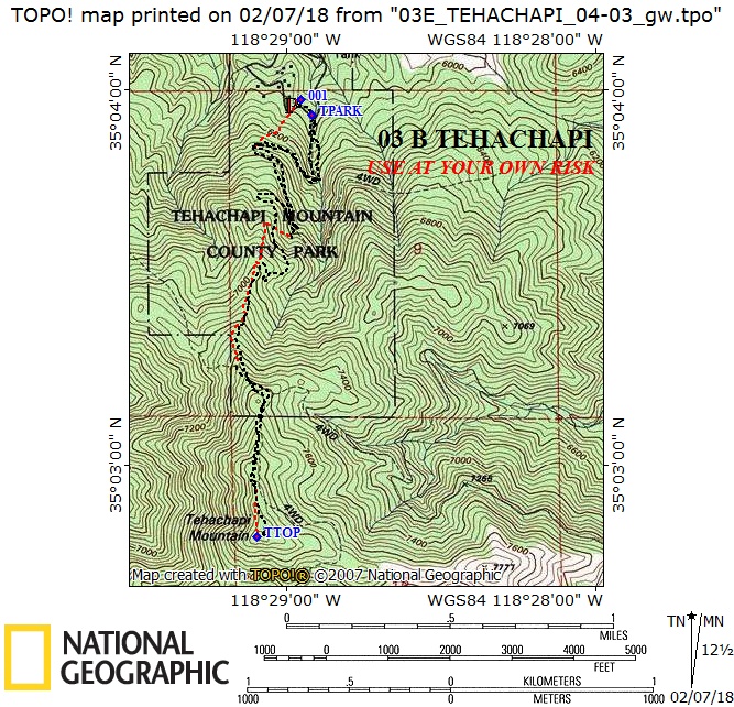
Distance: 4.4 miles round trip on road and cross-country
Gain: 2000'
Time: 3-4 hours round trip
Rating: Class 1, moderate

Original: Al Campbell, January 1974

DRIVING ROUTE 1

  • From Mojave, drive northwest on SR 58 about 21 miles to exit 148, the third Tehachapi off-ramp. It is labeled "Correctional Institution" and is SR 202 west.
  • Note your odometer as the exit ramp crosses the freeway, and continue generally southwards on what becomes Tucker Road.
  • At 1.1 miles, cross Valley Blvd. This is the turnoff for Black Mountain #3.
  • At 2.2 miles, an intersection with Highline Road. Turn right (west).
  • At 3.5 miles, Water Canyon Road on the left. Turn left (south).
  • At 5.7 miles, entrance to Tehachapi Mountain Park.
  • Continue through the park to the end of the road, keeping right at each fork, to a parking area at site 49 near some restrooms. Park here.

HIKING ROUTE 1

  • From the parking area (6000'), hike south up the slope to a road at 6300'.
  • Turn right on this road and follow it past several switchbacks to its end on the ridge at 7000' near a pile of light gray rock.
  • From here follow the ridge south to the summit.
Donate to HPS

Sign up to post your trip reports, photos and comments, and to receive occasional updates about news and events

Sign Up
HPS Official Logo round without shading small 1

Our club offers a variety of hikes suitable for all levels, from beginners to seasoned trekkers. Discover easy, moderate, or challenging trails and enjoy the camaraderie of fellow hikers while exploring stunning landscapes.

Peaks

  • Peak List
  • Outings
  • Emblems
  • Awards
  • Archives
  • Peak List
  • Outings
  • Emblems
  • Awards
  • Archives

About

  • About Us
  • Newsletter
  • Bylaws
  • Privacy Policy
  • Join the Sierra Club
  • About Us
  • Newsletter
  • Bylaws
  • Privacy Policy
  • Join the Sierra Club

Connect

  • Membership
  • Merchandise
  • Subscribe
  • Contact Us
  • Follow us on Facebook
  • Membership
  • Merchandise
  • Subscribe
  • Contact Us
  • Follow us on Facebook

© 2026 Hundred Peaks. All Right Reserved – Design by

Facebook-f Instagram Twitter Whatsapp