Goodykoontz Peak

Goodykoontz Peak, Photo by Steve Russell.

Peak Name

Goodykoontz Peak
13K

Elevation

7558

 feet

Status

active

Region

North Of Angeles Crest Hwy 2

Range

San Gabriel Mountains

Location

34.370033,-117.883504

Description

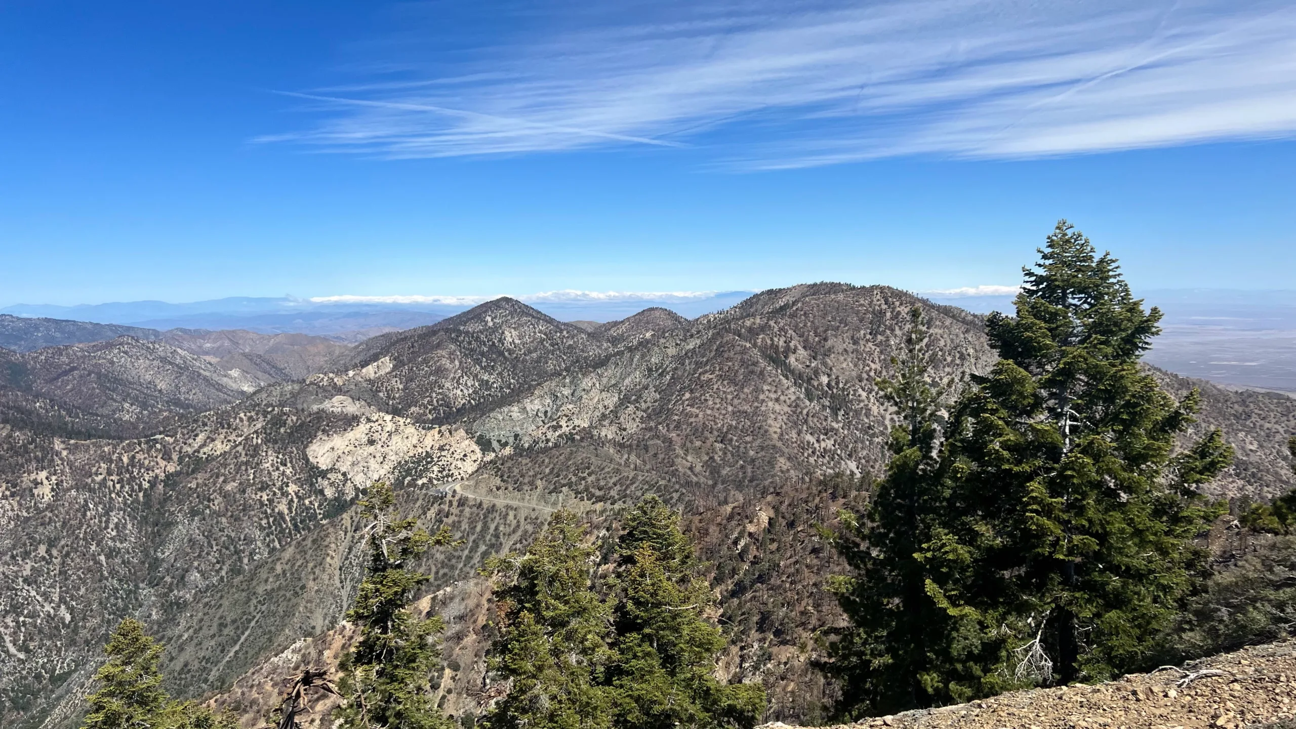
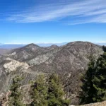
This peak is named informally for the prolific and much loved HPS leader Frank Goodykuntz, whose accomplishments in the 1970s and 1980s are described in the summit notes, and the name has stuck. This rocky peak has views of Pallett to the north and the peaks of the eastern San Gabriels.
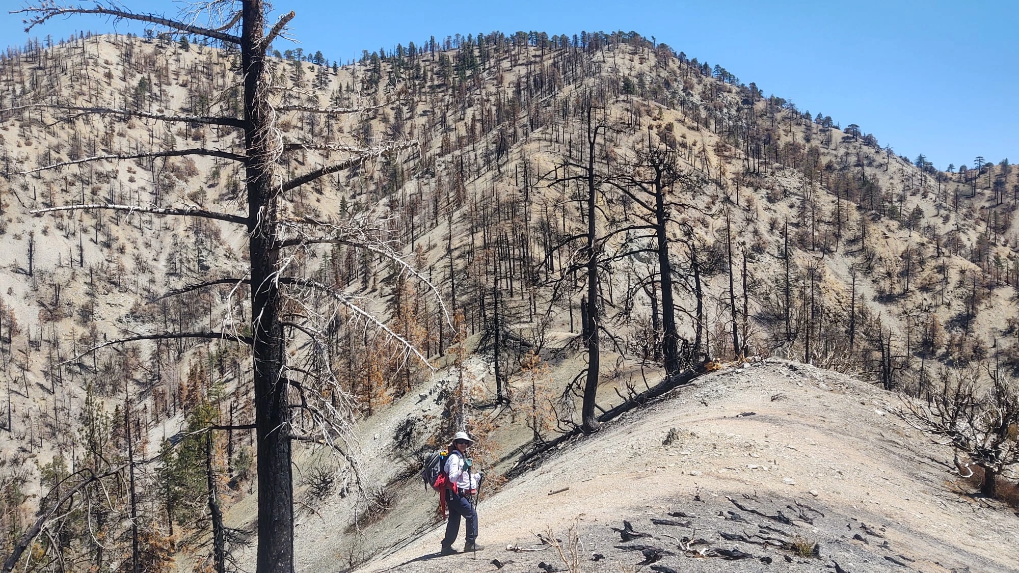
Route 1 was withdrawn because of the likely permanent closure for the mountain yellow-legged frog. Route 2 goes on a use trail on the ridge from Mount Williamson. Route 3 departs the Burkhart Trail and ascends cross country up the steep rocky west ridge of Bobcat Knob, a rocky outcropping, continuing on to the peak.
NOTE CONCERNING ANGELES FOREST CLOSURE ORDER
Goodykoontz Peak is located just north of an area subject to the following closure order:
In order to protect critical habitat of the mountain yellow-legged frog, the U.S. Forest Service will extend the Williamson Rock temporary closure until December 31, 2008. This is an ongoing closure which limits access to approximately 1,000 acres in the area north of the Angeles Crest Highway (SR 2) in the vicinity of Cooper Canyon and has been in place since December 2005. The new forest order becomes effective Tuesday, January 1, 2008. This order continues in effect indefinitely.
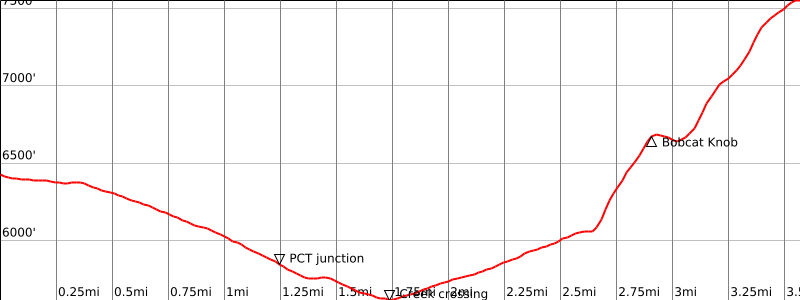
Convenient legal access to Goodykoontz Peak is provided by the Burkhart Trail, which is open to the public.
The peak is legally accessible as follows:
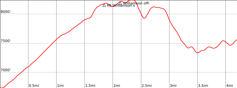
(1) from Pallett Mountain by following connecting ridgelines south to the summit;
(2) from Mount Williamson by following connecting ridgelines west and then southwest to the summit;
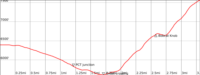
(3) from the Burkhart Trail by first ascending Bobcat Knob (6709′) via its west or northwest ridge, then continuing east for one mile to the summit.
Avoid the south ridge of Bobcat Knob; the Rattlesnake Trail; and all routes that begin from Rattlesnake Canyon.

Maps generated from CalTopo.com, reproduced with permission

Route 1- Climbers Trail from South- SUSPENDED
Elevation Gain
1300′ total, 1100′ out plus 200′ on return
Navigation Difficulty
Moderate
Distance
4 miles round trip
Estimated time
3-4 hours round trip
Route Rating
Class 1, strenuous
Leader Rating Required
I, normal conditions

Driving route

From the intersection of I-210 and Angeles Crest Highway (SR 2), drive north on Angeles Crest Highway 9.5 miles to Angeles Forest Highway. Keep straight.
Continue about 4.5 miles to the junction with the Mount Wilson Road at the Red Box Ranger Station. Keep straight.
Continue 24 miles to a large parking area on the left (north). This is 0.7 mile east of a large shed on the right. Park here.

Hiking route

The Pacific Crest Trail (PCT) leaves from the east end of the parking area (6680′). Look instead for a climbers’ trail a bit west of the PCT, that initially descends.
Follow the climbers’ trail down to a scenic wash, then up the other side and eventually around to a steep ridge.
Ascend the steep, usually open, ridge to the summit.

Route Notes

Note: Suspended due to US Forest Service closure order.

Printable Route

Road Type

Paved

Google Maps Link to Trailhead 

Route 2- From Mount Williamson
Elevation Gain
4200′
Navigation Difficulty
Moderate
Distance
10 miles between trailheads
Estimated time
6-7 hours (with short car shuttle)
Route Rating
Class 1, strenuous
Leader Rating Required
I, normal conditions

Driving route

From the intersection of I-210 and Angeles Crest Highway (SR 2), drive north on Angeles Crest Highway 9.5 miles to Angeles Forest Highway. Keep straight.
Continue about 4.5 miles to the junction with the Mount Wilson Road at the Red Box Ranger Station. Keep straight.
Continue 24 miles to a large parking area on the left (north). This is 0.7 mile east of a large shed on the right. Park here.

Hiking route

From the east end of the parking area, follow the Pacific Crest Trail (PCT) as it switchbacks up the southwest ridge of Mount Williamson.
After about a mile, at the top of the ridge, the PCT goes southeast to Islip Saddle. At this point, turn northeast and follow the use trail to the crest of the ridge.
Turn west and go about 1/4 of a mile to the summit of Mount Williamson at 8244′.
From there continue west along Pleasant View Ridge past bump 8248′, descend to the saddle and then up to the next bump at elevation 8160’+.
At bump 8160’+ find the ridge that starts at the top of this bump at a bearing of 260°. This ridge is not obvious at first and it is imperative that you find the correct ridge.
Follow the ridge as it gradually curves around toward the south to the summit.
Return to Buckhorn Campground following Route 3 – From West via Burkhart Trail.

Route Notes

From Mount Williamson.

Printable Route

Road Type

Paved

Google Maps Link to Trailhead 

Route 3- From the West via Burkhardt Trail
Elevation Gain
3000′ total, 2000′ out plus 1000′ on return
Navigation Difficulty
Moderate
Distance
10 miles round trip
Estimated time
5-6 hours round trip
Route Rating
Class 1, strenuous
Leader Rating Required
I, normal conditions

Driving route

From the intersection of I-210 and Angeles Crest Highway (SR 2), drive north on Angeles Crest Highway 33.5 miles to the entrance to Buckhorn Campground on the left. Turn left.

Proceed down the entrance road and turn left at the next two forks, then follow the signs “Burkhart Trail” to a large parking area.
If the Campground entrance is locked, drive SR 2 another 0.8 mile to the campground exit road, which intersects SR 2 at a sharp angle to the left. Park beside the exit road and hike down through the campground to the signed trailhead. This adds 1 mile and 200′ of gain to the round trip.

Hiking route

From the parking area (6460′), hike north down the Burkhart Trail (10W02) about 2 miles to a junction with the PCT just past Cooper Canyon Falls.
Turn right (east) on the PCT, crossing Little Rock Creek (5600′) in about 0.3 mile, and then proceed 100′ farther to a trail junction with the Rattlesnake Trail (signed).

Turn left to stay on the Burkhart Trail and head north for 1 1/2 miles until the trail meets the northwest ridge of Bobcat Knob (6709′). At this spot the trail begins an obvious descent into the bottom of the large canyon on your left (west).
Leave the trail here and ascend steeply to the Knob, then follow the main ridgeline east to the summit.

Route Notes

Printable Route

Road Type

Paved

Google Maps Link to Trailhead 

ROUTE 4 – From West via Burkhart Trail
Elevation Gain
2700′ total, 1900′ out plus 800′ on return
Navigation Difficulty
Moderate
Distance
6.5 miles round trip on trail and cross country
Estimated time
4-5 hours round trip
Route Rating
Class 1, strenuous
Leader Rating Required
“I”, normal conditions

Driving route

  • From the intersection of I-210 and Angeles Crest Highway (SR 2), drive north on Angeles Crest Highway 33.5 miles to the entrance to Buckhorn Campground on the left. Turn left.
  • Proceed down the entrance road and turn left at the next two forks, then follow the signs “Burkhart Trail” to a large parking area.
  • If the Campground entrance is locked, drive SR 2 another 0.8 mile to the campground exit road, which intersects SR 2 at a sharp angle to the left. Park beside the exit road and hike down through the campground to the signed trailhead. This adds 1 mile and 200′ of gain to the round trip.

Hiking route

  • From the parking area (6460′), hike north down the Burkhart Trail (10W02) about 2 miles to a junction with the PCT just past Cooper Canyon Falls.
  • Turn right (east) on the PCT, crossing Little Rock Creek (5600′) in about 0.3 mile, and then proceed 100′ farther to a trail junction with the Rattlesnake Trail (signed).
  • Turn left to stay on the Burkhart Trail and head north for 0.25 mile, where the trail passes a shallow gully on the right coming down from a ridge which heads north up to Bobcat Knob (6709’).
  • Leave the trail here and proceed 0.1 mile up the gully to gain the ridge.
  • Take the ridge to Bobcat Knob, then follow the main ridgeline east to the summit.

Route Notes

Printable Route

Road Type

Paved

Google Maps Link to Trailhead 

Additional Peak Information

Notes: A secondary bump 1/4 mile north of the official register location is slightly taller (7560+) than the recognized summit.
This peak was named after Frank Goodykoontz who was the first HPS leader to lead the entire list four times. He also completed the list nine times. In 1986 he received the John Backus Service Award, in 1988 the Chapter’s Outings Service award, and in 1999 he received a special HPS Leadership service award which had never been given in the past.

Nearby Peaks

Backus Peak
Owens Peak
Black Mountain #5
Morris Peak

External Links

mountain 1

Peakbagger.com

Click Here

ranger-tower 1

Nearest ranger station

Click Here

g311

NOAA Forecast

Click Here

worldwide 1

Google Earth

Click Here

Photo Gallery