• HOME
  • HIKE WITH US
    • Peak Guides
    • Outings
    • HIKE FINDER
    • Emblems
    • Archives
  • ABOUT
    • About Us
    • Newsletter
    • FAQ
  • CONNECT
    • Membership
    • Merchandise
    • Subscribe
    • Follow Us on Facebook
    • Sierra Club
    • Donate
    • Contact US
LOG IN
LOG IN
  • HOME
  • HIKE WITH US
    • Peak Guides
    • Outings
    • HIKE FINDER
    • Emblems
    • Archives
  • ABOUT
    • About Us
    • Newsletter
    • FAQ
  • CONNECT
    • Membership
    • Merchandise
    • Subscribe
    • Follow Us on Facebook
    • Sierra Club
    • Donate
    • Contact US

Pilot Knob

USE AT YOUR OWN RISK

01G

Pilot Knob (DeListed)

6200'+

Location: Kern County, about 2.5 miles north-northeast of the town of Onyx, 155 miles from Los Angeles

Maps

Auto Club Kern County
Forest Service Sequoia National Forest
USGS Topo Onyx 7½
Official HPS Maps TPO file - Save to your computer then open with National Geographic TOPO!
  Viewable JPG file - Approximately 370K
  GPX file or Google Earth KML file to download to GPS units and other map software (How to use GPX and KML files)
  Routes as shown on CalTopo using the above files (How to use CalTopo)

ROUTE 1

Distance: 6 miles round trip cross-country
Gain: 3400'
Time: 8-10 hours round trip
Rating: Class 2, very strenuous
Navigation: Moderate
Leader Rating: "I", normal conditions

Original: Charlie Knapke, October 1988

DRIVING ROUTE 1

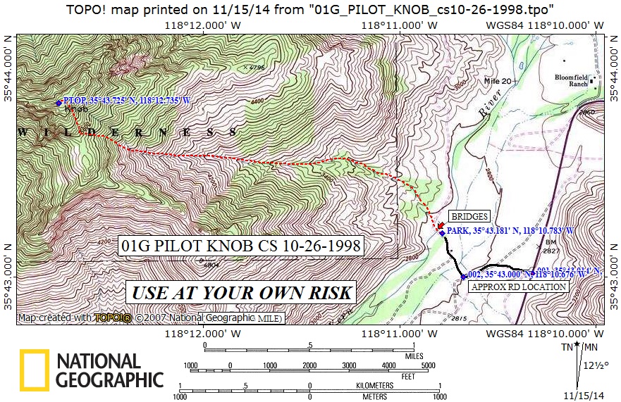
  • From Mojave go north on SR 14 to the intersection with SR 178 (Walker Pass Road). Turn left.
  • Go west on SR 178 for about 23 miles to Bloomfield Ranch Road (paved, on right side). At this spot SR 178 makes a giant turn south. Go 0.8 mile further to a dirt road on the right. Turn right.
  • Note your odometer and go as follows:
  • At 0.3 and 0.35 mile, forks. Go straight.
  • At 0.4 mile, several buildings with a bridge. Park on the right near the trailers before the bridge. This is private property. Do not proceed (either by car or on foot) without permission from the property owner(s).
  • Alternatively, park on the highway and hike the 0.4 mile.

HIKING ROUTE 1

  • From the parking area (2800'), cross the bridge on the south fork of the Kern River.
  • Continue north up the road about 50 yards and find a cattle trail heading to the left. In another 100 yards a large canyon opens up to the left (west). This canyon is an alternative route, but is typically very brushy.
  • Leave the road and hike up the cattle trail, then over a minor rise on the right, then down into the canyon. Note this location for your return.
  • Staying generally on the slopes north of the main canyon, ascend steeply to a saddle (5520'+) just south of the peak. The rocks in the canyon bottom are polished and very slippery. The route to the north of the canyon bottom can look difficult, but usually turns out to be easily passable.
  • Turn right and follow a well-ducked trail up to the summit.
  • Keep to the right of the rock outcroppings near the top. The register is on the west summit block.
Donate to HPS

Sign up to post your trip reports, photos and comments, and to receive occasional updates about news and events

Sign Up
HPS Official Logo round without shading small 1

Our club offers a variety of hikes suitable for all levels, from beginners to seasoned trekkers. Discover easy, moderate, or challenging trails and enjoy the camaraderie of fellow hikers while exploring stunning landscapes.

Peaks

  • Peak List
  • Outings
  • Emblems
  • Awards
  • Archives
  • Peak List
  • Outings
  • Emblems
  • Awards
  • Archives

About

  • About Us
  • Newsletter
  • Bylaws
  • Privacy Policy
  • Join the Sierra Club
  • About Us
  • Newsletter
  • Bylaws
  • Privacy Policy
  • Join the Sierra Club

Connect

  • Membership
  • Merchandise
  • Subscribe
  • Contact Us
  • Follow us on Facebook
  • Membership
  • Merchandise
  • Subscribe
  • Contact Us
  • Follow us on Facebook

© 2026 Hundred Peaks. All Right Reserved – Design by

Facebook-f Instagram Twitter Whatsapp