The Yucaipa Ridge is a relatively narrow east-west trending ridge in San
Bernardino County that is located south of San Gorgonio Mountain and north of
San Jacinto Peak. The Ridge is highest on its eastern edge where it rises more
than 7,000' above the town of Banning; from east to west it loses more than
5,000' in elevation over about 10 miles. The views from atop the Ridge are
spectacular and are likely the reason that a few of the peaks along it were
included as part of the original 1946 HPS List. To the south are magnificent
vistas of San Jacinto and the awesome San Andreas Fault Zone which carves out
the whole Banning Pass area far, far below; to the north the boulder-strewn wash
of Mill Creek and the steeply rising forested slopes and grassy gullies of the
San Gorgonio group are spectacularly in view.
Currently the HPS has seven named peaks along the Yucaipa Ridge. From east to
west (and highest to lowest) they are: Galena Peak (9,324'), Little San
Gorgonio Peak (9,133'), Wilshire Mountain (8,832'), Wilshire Peak (8,680+),
Cedar Mountain (8,324'), Birch Mountain (7,826'), and Allen Peak
(5,796'). While it is possible to hike the entire Yucaipa Ridge from
Galena Peak to Allen Peak as one continuous day hike, the section between Galena
and Little San Gorgonio is reported to cover severely rugged terrain that
requires a great deal of comfort and experience on class 3 rock. We decided to
break our traverse of the Yucaipa into two segments; the first a Saturday hike
to Galena Peak and back, the second a traverse along the ridge from Little San
Gorgonio to Allen Peak on the following Saturday.
On Saturday July 9, 2011 a group of 11, led by Peter & Ignacia Doggett and
co-led by Chris Spisak, Lilly Fukui, and myself set out from the Vivian Creek
Trailhead parking lot up the boulder filled streambed of Mill Creek. Evidence of
the scale of this past year's strong winter and spring storms was abundant as we
headed upstream toward the Mill Creek Jumpoff; fresh debris slides seemed to
have piled up and issue out of every little major and minor side canyon and
gully we crossed. Water cascaded from numerous gullies high up canyon walls,
primarily on the northern side, indicating continued erosion is still in
progress. As we approached the "Headwall" it seemed that we encountered more and
more freshly fallen mud and rock in the streambed; it looked as if it had only
just recently hardened as its storm-derived water suddenly drained out of it.
Ignacia thought the Headwall itself was in about the worst shape she's ever seen
it in her many times there; it was especially loose and nearly devoid of any
hand or foothold. But once we were on the Headwall, Peter and Ignacia expertly
guided us across its slippery surface. Not enough can be said about how
knowledgeable and patient those Doggetts were in explaining and demonstrating to
us exactly how to safely get both up and then back down the headwall. I think I
can safely say that every one of us who were on that outing feels a debt of
gratitude to Peter and Ignacia for their patient and gracious assistance.
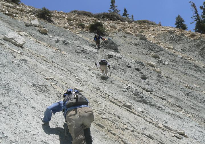
Traversing across the Galena Headwall. From bottom of photo up and
to the right: Mari Sakai, Lilly Fukui, Pieter Kaufman. Peter Doggett in
yellow behind gray boulder, Ignacia Doggett to the right. Photo by Mat
Kelliher.
Once we'd crossed the headwall we ate a little lunch and then climbed steeply up
to the summit. As we climbed we were treated to magnificent views of the Mill
Creek drainage below us; at spots our route would expose open vistas with
dizzying drop offs, seemingly thousands of feet of empty air between us and the
streambed below. On the summit of Galena we were treated to our first view south
from the Yucaipa Ridge; an astonishing glimpse of San Jacinto with the Banning
Pass so far below, to the southeast way out into the flat depression of the
Salton Trough, to the east to the badland topography that borders the western
edge of Joshua Tree, to the west a vague hint at the extent of the entire
Yucaipa Ridge which could only just be made out behind West Galena and through
the afternoon haze. We came back down from the summit, across the Headwall, and
back down to the trailhead without incident. Of the 11 who started out on our
adventure, 10 made it across the Headwall, and nine made it to the summit. All
of us made it back to the cars. Including the leaders and co-leaders already
mentioned, the participants included Tanya Roton, Stella Cheung, Laura
Franciosi, Mari Sakai, Pieter Kaufman, and Jessie Slater.
On the following Saturday July 16, 2011 a group of 9, led by myself and Jim
Fleming and co-led by Winnette Butler, Chris Spisak, and Lilly Fukui, met at the
Mill Creek Ranger Station in Mentone, CA. After having previously been granted
permission along with the current gate key code, we drove into the Bear Paw
Preserve where we parked about half of our vehicles. Those who parked hopped
into the non-parked cars and we drove over to the Vivian Creek Trailhead parking
lot. Once there we quickly got our boots tied up and our gear lashed down, and
off we went; up Mill Creek on our way to Little San Gorgonio Peak. After about ¾
mile I led our group south and headed up a gravel wash east of Camp Creek and
then up its adjacent very, very steep forested ridge on the north side of the
Yucaipa Ridge. We took our time getting up the steep - over this section of
about 2 miles we'd gain nearly 3,300', no reason to rush through it. At the top
of the steep ridge we were treated to a short traverse along its very narrow top
as we headed southeast towards the saddle at 8,440'; we got our first glimpse of
the north side of Little San Gorgonio and a jaw-dropping view of the Mill Creek
wash way, way, way down below us from along this ridge top. Soon our ridge
intersected the Yucaipa Ridge where we turned west and after climbing steeply we
were on the summit of Little San Gorgonio. We had lunch on the summit while
enjoying the magnificent views of Galena and West Galena to our east, to the
south we were treated to fantastic views of San Jacinto and the Banning Pass
below with pine topped crags and lots of empty air framing that scene; to the
north Gorgonio, Jepson, and Dobbs stood silently above their pine and grass
covered slopes. To the west the pine-covered, craggy bumps composing our still
unexplored portion of the Yucaipa Ridge lay before us.
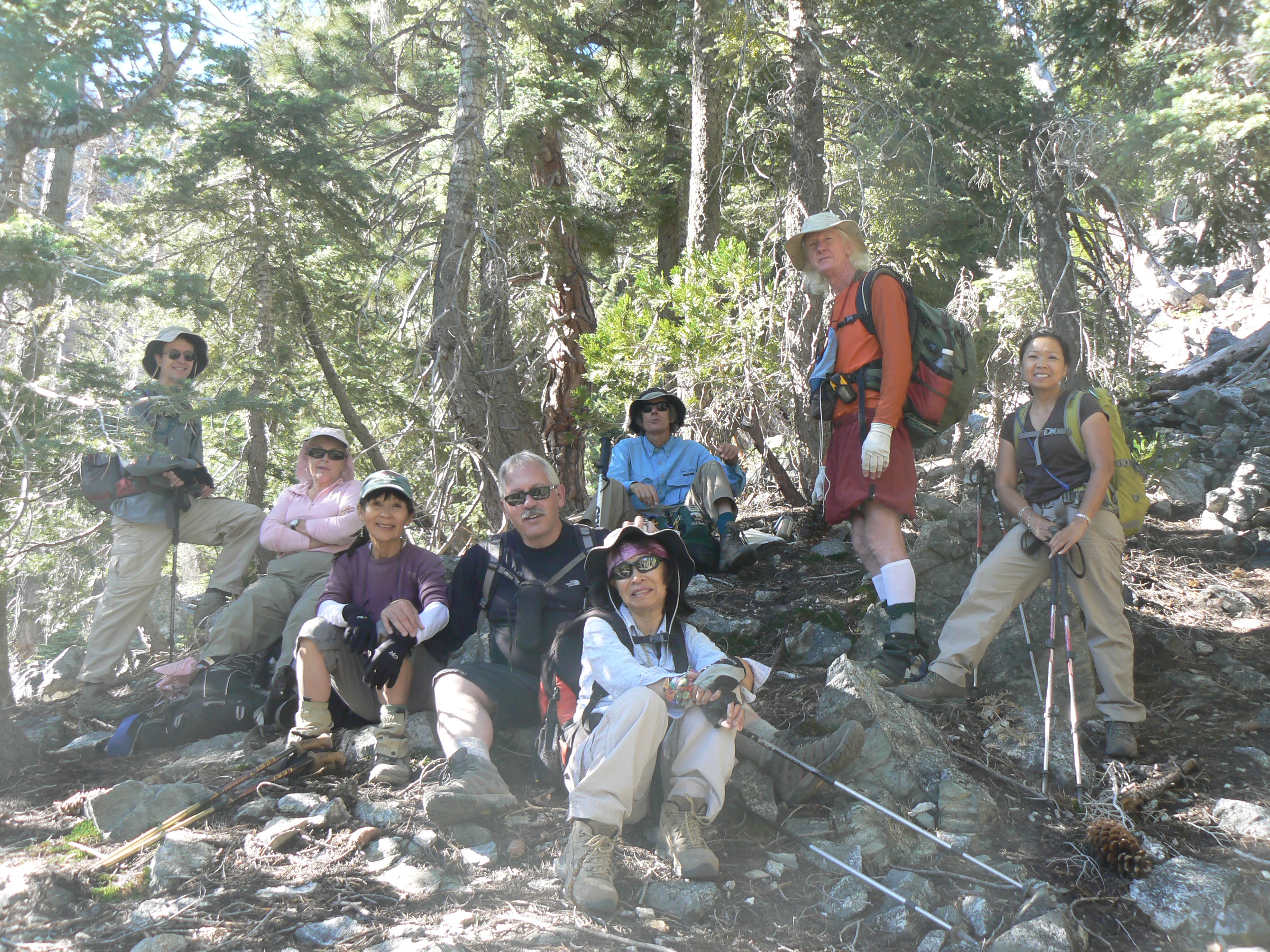
Somewhere up the Steep enroute to Little San Gorgonio Peak. Left to
right: John Slagle, Winnette Butler, Lilly Fukui, Chris Spisak, Jim Fleming,
Stella Cheung, John 'Pinetar' Wilson, Tanya Roton. Photo by Mat Kelliher
From Little San Gorgonio Jim led us west on our traverse across the ridge top
through the trees with beauty all around us. The weather was perfect up there
with temperatures in the high 60's - low 70's and an occasional gentle breeze
coming in from the south. It was a short and easy little stroll to Wilshire
Mountain. From Wilshire Mountain Winnette led us on a pleasant walk along the
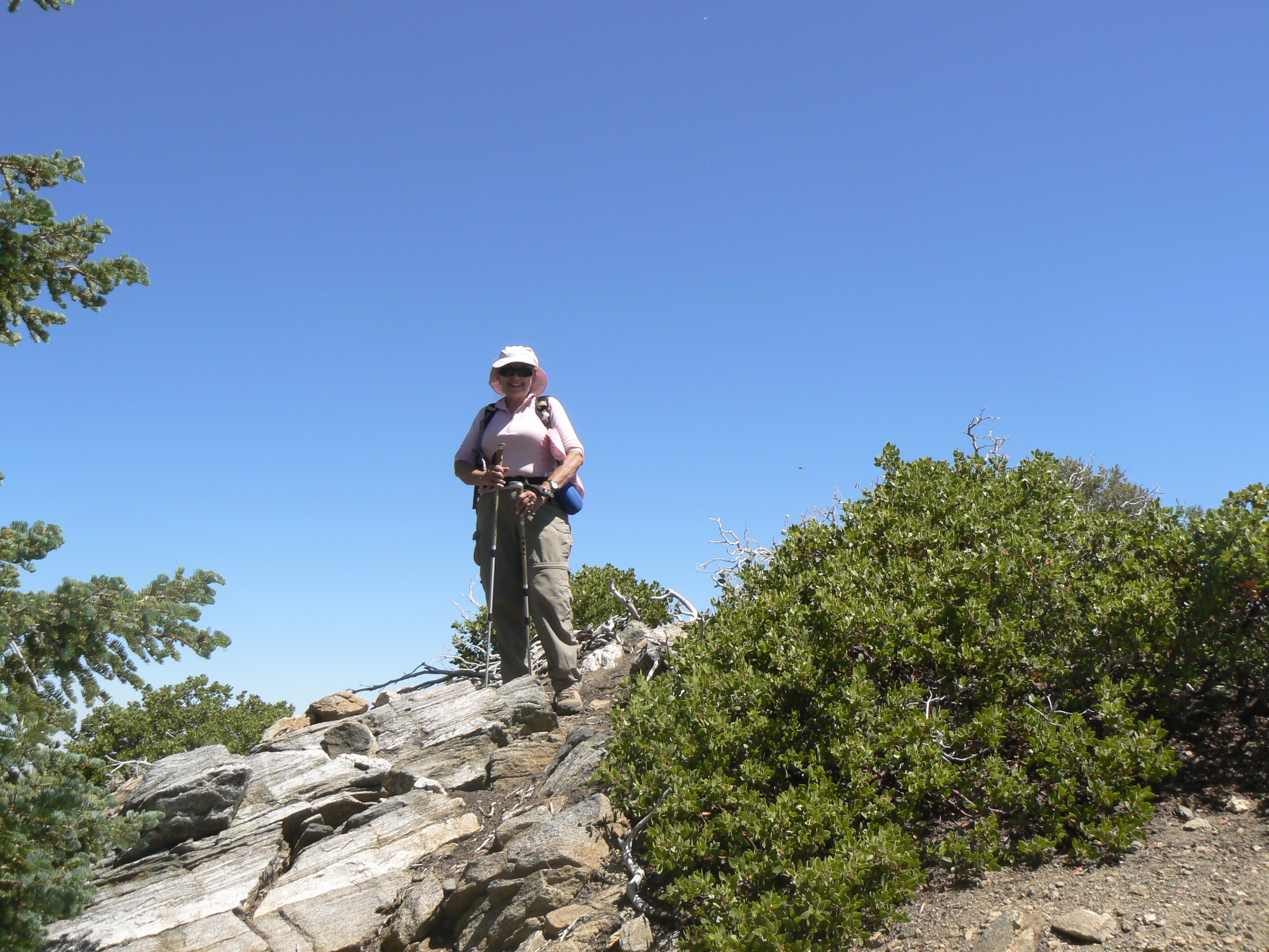
ridge and through the trees to Wilshire Peak; once on the summit of Wilshire
Peak we congratulated Winnette on her 100th HPS Peak lead!, and helped
her
finish off her celebration cookies.
Winnette Butler's 100th Lead
July 16, 2011 on Wilshire Peak
Photo by Mat Kelliher
From Wilshire Peak Lilly led us to Oak Glen Peak. For reasons unknown to any of
us, Oak Glen Peak isn't on the HPS List, but it's an awfully nice peak anyway
and it has a register, so we all signed in there and continued on our way. Chris
led us west from Oak Glen Peak to Cedar Mountain on a traverse that took us down
in elevation several hundred feet and then right back up; definitely tougher
than what we'd seen on the ridge top so far. From Cedar Mountain Jim led us west
to Birch Mountain. The traverse along this section was tough; lots of up and
down followed by a very steep ascent to the summit of Birch. Once on Birch we
happily made note that we were more than half way through our journey, and all
admitted to feeling a little tired. From Birch I led us west towards the
Allen-Birch summit, but while on the vague use trail some distance down from the
summit I took a wrong turn that landed us all in the brush for a little while.
Jim's keen navigational skills soon got us back on a well defined trail; it
turns out we hadn't been too far from it at all. Soon the trail turned to a fire
road in very good condition and as we hiked down it the sun set in the west
behind Allen Peak while the one-day-old full moon rose in the east.
At the Allen-Birch Saddle most of our group returned to the cars. But Jim
Fleming, John Slagle, and I continued west through the warm summer night over
first road and then well defined use trail to the summit of Allen Peak where we
were treated to vast views of a slightly moon washed starry night sky with the
dark silhouettes of nearby landforms to our east and below us. We arrived back
at the cars about an hour after the rest of the group did. Including the leaders
and co-leaders already mentioned our participants included Tanya Roton, Stella
Cheung, John Slagle and John 'Pinetar' Wilson. All of us owe and offer our
thanks to the Wildlands Conservancy for permission to enter and use the Bear Paw
Preserve, and especially to Evan Welsh for his assistance in providing access
information and sharing his first-hand knowledge of current conditions that he
obtained during his traverse of the entire Yucaipa Ridge (Galena to Allen)
earlier this year in June.