HOME
HIKE WITH US
Peak Guides
Outings
HIKE FINDER
Emblems
Archives
ABOUT
About Us
Newsletter
FAQ
CONNECT
Membership
Merchandise
Subscribe
Follow Us on Facebook
Sierra Club
Donate
Contact US
Search ...
Results
LOG IN
Search ...
Results
LOG IN
HOME
HIKE WITH US
Peak Guides
Outings
HIKE FINDER
Emblems
Archives
ABOUT
About Us
Newsletter
FAQ
CONNECT
Membership
Merchandise
Subscribe
Follow Us on Facebook
Sierra Club
Donate
Contact US
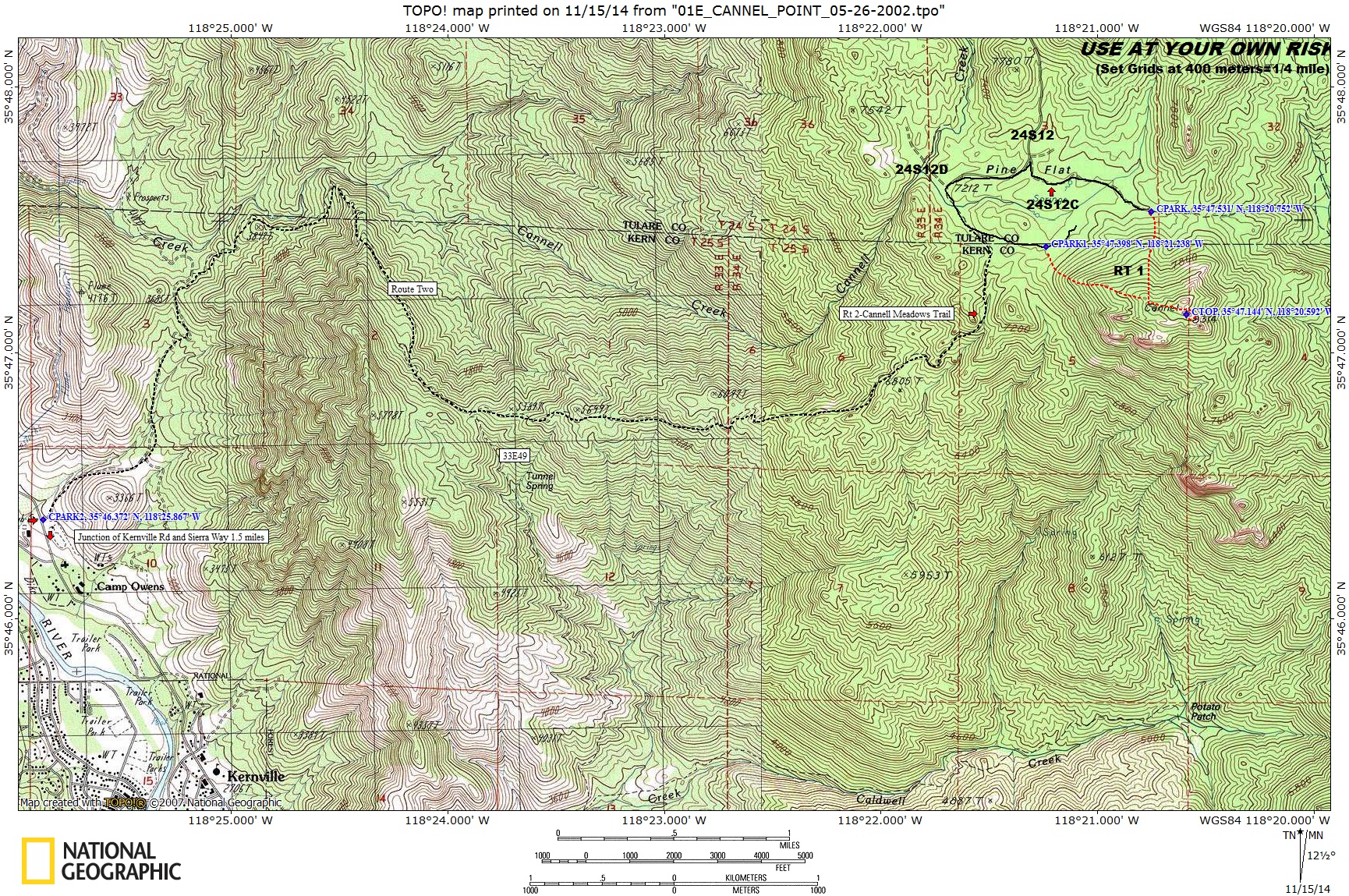
Cannel Point (DeListed)
USE AT YOUR OWN RISK
01E
Cannel Point
(DeListed)
8314'
Location: Kern County, about 5 miles northeast of Kernville, 210 miles from Los Angeles
Maps
Auto Club
Kern County
Forest Service
Sequoia National Forest
USGS Topos
Cannel Peak 7½, Weldon 7½
Official HPS Maps
TPO file
- Save to your computer then open with National Geographic TOPO!
Viewable
JPG file
- Approximately 1.5 megs
GPX
file or Google Earth
KML
file to download to GPS units and other map software (
How to use GPX and KML files
)
Routes as shown
on CalTopo
using the above files (
How to use CalTopo
)
ROUTE 2
Distance:
24 miles round trip on trail and cross-country
Gain:
5500'
Time:
12 hours round trip
Rating:
Class 1, strenuous, class 2 summit block
Leader Rating:
"I", normal conditions
Navigation:
Intermediate
Original:
Byron Prinzmetal, 2002
DRIVING ROUTE 2
From the intersection of Kernville Road and Sierra Way in Kernville (see Route 1), turn left (north) on Sierra Way.
Drive north on Sierra Way for 1.5 miles to a parking area on your right. Park here.
HIKING ROUTE 2
From the parking area hike up Cannel Meadows Recreational Trail (33E22) for about ten miles until you reach Pine Flat.
From there go east on the road at the intersection of Cannel Meadows Trail and 24S12D for about 1/2 mile.
Then follow Route 1 directions to the top.
Donate to HPS
Sign up to post your trip reports, photos and comments, and to receive occasional updates about news and events
Sign Up
CLOSE


